IMPORTANT: These Rotary Screw Traps will be operating in the river from December 2024 to May 2025
Rocky Rest Campground
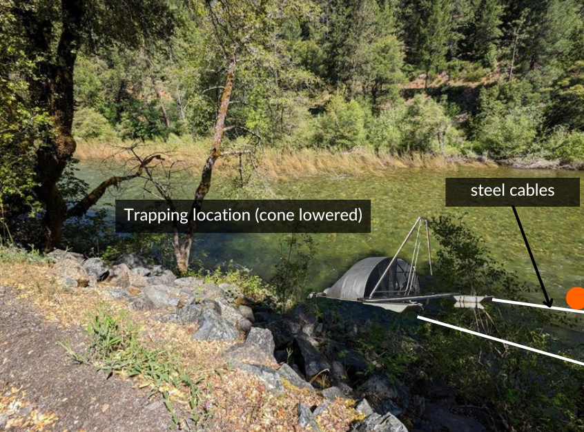
Rocky Rest Campground is located off of Hwy 49 in Camptonville, CA about 10 miles west of Downieville, CA. At this site, the rotary screw trap (RST) is anchored to a cable elevated well above the water surface and suspended between two large trees upstream of the walking bridge. The Rotary Screw Trap is tethered to that cable using two “leader” cables. In this way operators will be able to be adjust the trap upstream and downstream as flows change, or readily move it out of the main current in the event of high water.
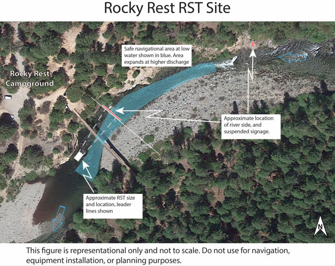
The leader cables and cross river cable are not expected to cause an undue risk to individuals paddling this stretch of river. Appropriate warning signage has been placed well upstream of the trap and will provide community-standard safety instructions “pointing positive” towards the safe passage route. Large signs have been installed on the clear outcropping on river right about 400 feet from the trap, pointing positive in the direction of safe passage around the trap to river left. Additional signage at the campground will warn river users of the risk of walk or climbing on the bank upstream of the trap. Additionally, flagging has been attached to the steel leader cables to aid in their visibility from the water, although most of the length of the cables will be sufficiently above the water surface so as not to pose a hazard to whitewater boaters.
Safe passage around this Rotary Screw Trap is river left, paddling away from the river right bank. This is the normal path of travel for boats at this location.
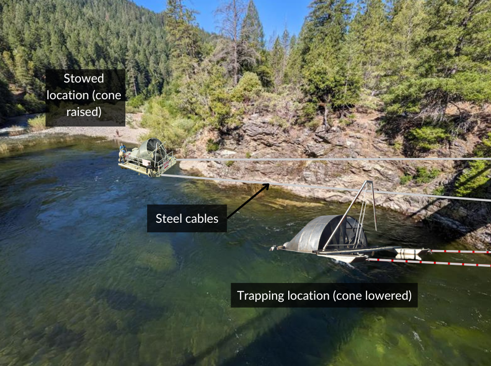
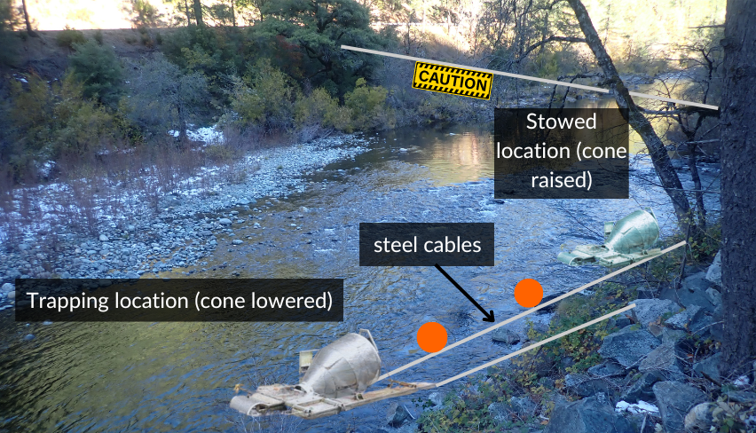
The figure above illustrates the approximate size and location of the trap, locations of onshore signage and safe passage. As water levels increase, passage on the left will become easier. Below is a schematic of what the trap will look like at Rocky Rest Campground while it’s being operated and stored. The base photo was taken looking downstream from the footbridge.
For visualization purposes only
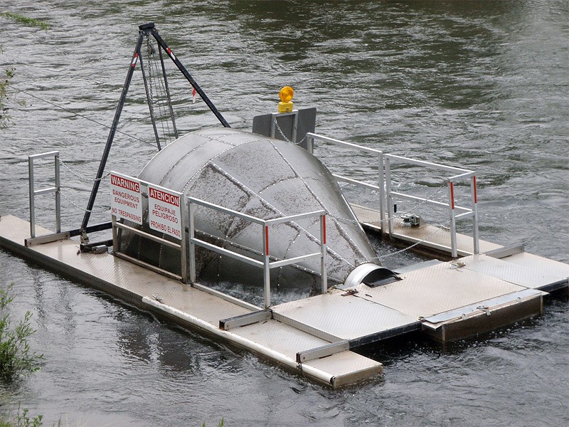
Photos from the Rocky Rest Rotary Screw Trap Installation on 10/11/23
Photos by FishBio


The Old Toll Bridge Road site is no longer being used for Rotary Screw Traps
The Rotary Screw Trap off of Old Toll Bridge Road was located approximately 0.5 miles upstream of the intersection of Mountain House Rd and Old Toll Bridge Road, upstream of the community of Goodyears Bar. At this site, the trap had been installed using one cable running upstream, at water level, to a cluster of alders near a natural backwater feature. A second cable had been anchored directly to shore, keeping the trap close to the river-left bank. A single, lightweight cable had been run between two trees to suspend an in-water hazard sign hung well above the surface of the water.
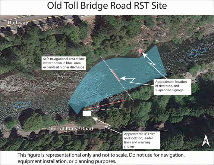
The risk of river-user interaction with this Rotary Screw Trap was significantly lower than at Rocky Rest Campground. River users were unlikely to encounter this trap traveling downstream due to the boxed in canyon and difficult whitewater (class V) upstream.
Unlike at Rocky Rest Campground, an added risk at this site arose from the surface cable anchoring the Rotary Screw Trap which was nearly invisible to those traveling on the water and had some moderate current pushing towards it at some flows. To mitigate this risk, channel edge signage and suspended signage warning boaters of the in-water hazard following the community standard of “pointing positive” were installed. Additionally, an additional line had been placed on the outside (towards the middle of the channel) of the trap’s leader line with buoys or other high visibility markers so that anyone traveling in the river had a visual marker of the partially submerged cable.
Safe passage at this location was on river right, moving right across the majority of the current which will be flowing right to left. This was slightly counterintuitive to normal navigation at this location, but easy to do.
The figure above illustrates the approximate size and location of the Rotary Screw Trap, locations of onshore signage, and area of safe passage. As water levels increase, passage on the right would become easier. Below are two schematics of what the trap looked like off Old Toll Bridge Road while it was being operated and stored.
For visualization purposes only
For visualization purposes only
Photos of the Old Toll Bridge Rotary Screw Trap Installations on 10/12/23
Photos by FishBio


